Upper Stevens Creek County Park (Stevens Canyon-Skyline Boulevard area)
OTE Ratings: O6/T5/E6(Grizzly Flat)-E8(Charcoal Road)
Distance: variable
Time: variable
USGS 7.5' topo: Mindego Hill, CA

Description
This park - part of a large cluster of open space areas in the hills behind Cupertino - contains two connecting trails between Stevens Canyon
(part of the Montebello Open Space Preserve)
and Skyline Boulevard
(the Long Ridge
and
Saratoga Gap Open Space Preserves).
(These trails are actually fire roads, except for a short segment of singletrack at the bottom, near the creek.)
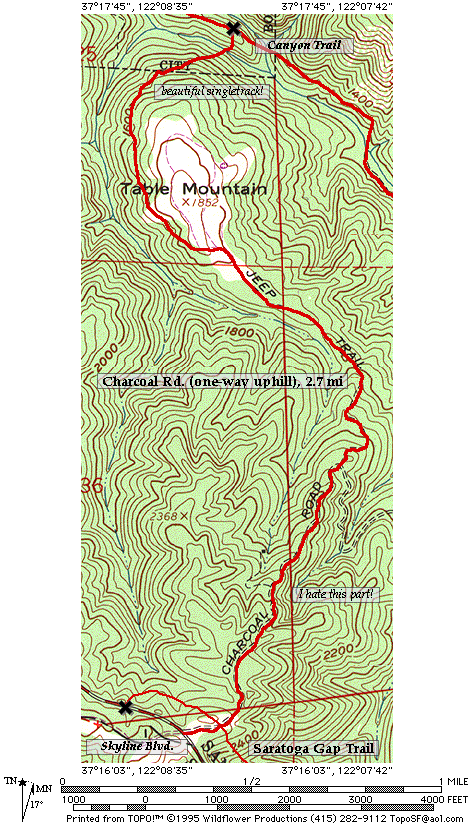
The northernmost of these two trails - "Grizzly Flat" - can be ridden uphill or downhill, but the southernmost trail - "Charcoal Road" - is open
to bikes in the uphill direction only.
Please respect this restriction.
Agreed, it's a real bummer not to be able to ride Charcoal Rd. downhill, but
the singletrack section at the bottom is very pretty and quite narrow,
and we're lucky to be able to ride it at all.
(The MROSD can be
rather anal about the width of the trails that it designates "multi-use".)
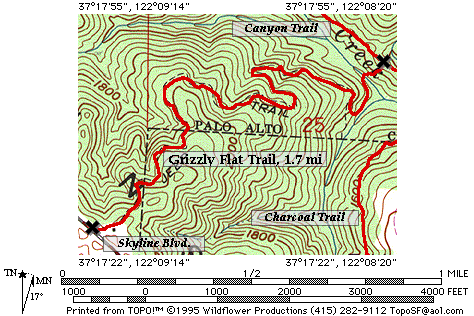
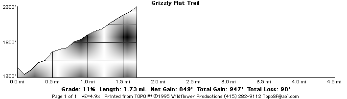
"Grizzly Flat" is by far the easier of the two trails to climb on, with a very even grade over its 1.7 mile length.
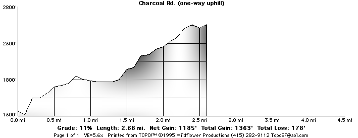
In contrast, the upper section of "Charcoal Rd." is very steep, and can be a rather hot
climb on a summer day.
(Each year I ride it once, just to remind myself how nasty it is.)
Directions to the start
The lower ends of these trails are reached from the "Canyon Trail" in
Montebello Open Space Preserve.
The upper end of "Grizzly Flat" trail is on Skyline Boulevard (highway 35), a few miles south of Alpine/Page Mill Road.
(N 37° 17.5', W 122° 09.1')
This is also directly across the road from the northern end of the trail system in
Long Ridge Open Space Preserve.
The ride
Grizzly Flat trail
Note that there are actually two, parallel, sections to the "Grizzly Flat" trail.
The older section runs from Skyline Boulevard to Stevens Canyon.
The newer section - not shown on the map below -
also starts out at Skyline Boulevard, and rejoins the older
section about 2/3 of the way down.
The newer section is the steeper of the two, and makes the better descent.
If you're riding down from Skyline Boulevard, choose the right-hand path.
If you're riding up from Stevens Canyon, then stay on the main fire road, and ignore the trails that branch to the left as you climb.
Charcoal Road trail
Return to the mountain biking page
©1995-2019 Ross Finlayson
(Topographical maps and elevation profiles created with TOPO!TM ©Wildflower Productions)