Monte Bello Open Space Preserve (between Cupertino & Skyline Blvd.)
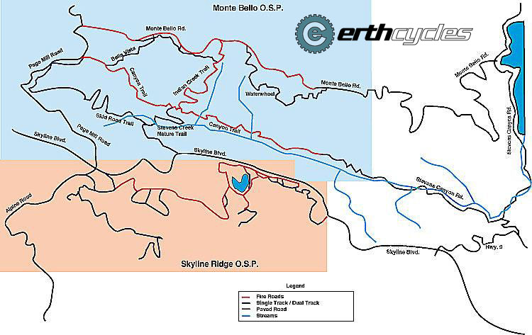
(This map of Monte Bello O.S.P. and the adjacent Skyline Ridge O.S.P. is courtesy of John Blenio)
OTE Ratings: O7/T4/E8
Distance: 17 miles
Time: 2.5 - 3 hours
USGS 7.5' topo: Cupertino & Mindego Hill, CA

Description
This large open space preserve provides a convenient way to reach the Skyline Boulevard region
(and its numerous trails) from the Cupertino area.
It includes the popular Canyon Trail: a combination fire road and singletrack
trail that traverses Stevens Canyon (which, incidentally, is part of the
San Andreas earthquake fault).
The preserve also includes the upper, unpaved section of Montebello Road.
This page describes a popular 17-mile loop: a climb up Montebello Road (paved and unpaved), a descent down the Indian Creek and Canyon Trails (fire road and singletrack), and finally a return via Stevens Canyon Road (paved).
Directions to the start
(N 37° 17' 53", W 122° 04' 42")
From I-280, take the Foothill Expressway exit, and continue south on Foothill Expressway
as it crosses Stevens Creek Boulevard.
(Somewhere around here, it changes its name to Stevens Canyon Road.)
Continue on this road until it reaches Stevens Creek Reservoir, and park in the lot
beside the road, next to the dam.
Montebello Road (the start of the measured loop) is about 1/4 mile further along
Stevens Canyon Road.
The ride
We describe this ride in three segments.
(A high-resolution topographical map of this loop is also available (393 KB).
[Map created with TOPO!TM ©Wildflower Productions])
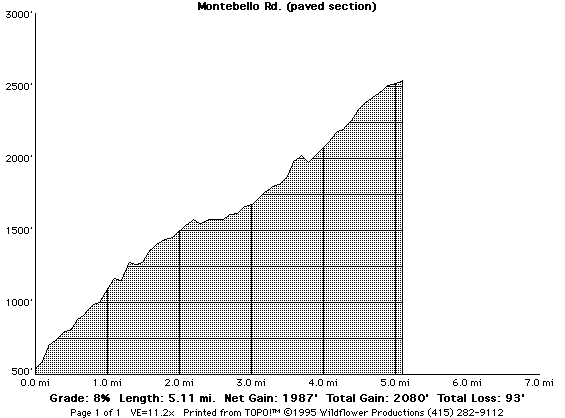
Up Montebello Road (paved)
Make the sharp right turn onto Montebello Road, and begin the long (5.1 mile) climb to the gate at the
end of the paved section.
Some sections of this climb are quite steep, but fortunately there's a flat section
about halfway through that eases the pain.
This is one of the better-known road climbs in the Bay Area.
Start a stopwatch running as you turn onto Montebello Road, and see how
long it takes you to reach the gate.
Amazingly, roadies have been known to complete this climb in only
25 minutes!
I'm usually content to complete the climb in under an hour.
Down into Stevens Canyon (dirt!)
Continue past the gate along the dirt section of Montebello Road.
(An alternative here is to take the fire road that you will have seen on the left about 1/4 mile before the gate.
This fire road - the "Waterwheel Creek Trail" - loops around and rejoins Montebello on the other side of the gate.)
In either case you end up continuing to climb on Montebello, eventually reaching the summit of Black Mountain, where you'll see lots of antennas, and
an expansive view of Silicon Valley.
Now the fun begins: an almost continual descent (on dirt) down Stevens Canyon!
Shortly after the summit, take the "Indian Creek Trail" (really, a fire road) to the left, as it descends into the canyon.
It's possible to go very fast on this section - just hypothetically, of course, because the speed limit for bikes is 15 miles per hour :-)
(An alternative route, which I sometimes prefer, is to descend on the next trail - "Bella Vista" - instead of on "Indian Creek".
"Bella Vista" is a narrower trail. You can't go as fast on it, but it feels
a bit more like singletrack.)
When you reach the bottom of "Indian Creek" (or "Bella Vista"), turn left onto "Canyon" trail.
Apart from a couple of minor uphill sections, this trail is completely downhill,
narrowing as it descends through the trees deeper into the canyon.
Ignore the trails that branch to the right ("Stevens Creek Nature Trail", "Grizzly Flat", and "Charcoal Rd."), unless you wish
to climb back out of the canyon up to Skyline Boulevard (highway 35).
After a couple of creek crossings, the trail reaches a gate, and the
beginning of the paved section of Stevens Canyon Road.
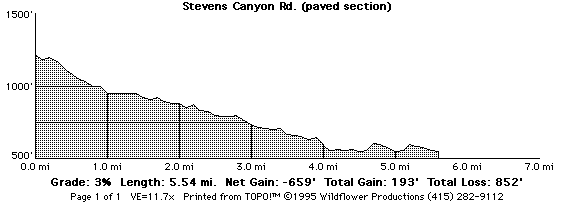
Back along Stevens Canyon Road (paved)
The ride along the paved section of Stevens Canyon Road is a fast, big-chainring fun roadie-type ride.
(Be careful though, because the top section of this road is narrow, and can be slippery during the wet season.)
Eventually you'll reach the junction with Mount Eden Road.
Continue left on Steven's Canyon Road to return to the bottom of Montebello and
complete the loop.
For more information
Return to the mountain biking page
©1995-2019 Ross Finlayson
(Elevation profiles created with TOPO!TM ©Wildflower Productions)