Wilder Ranch State Park (West of Santa Cruz)

map
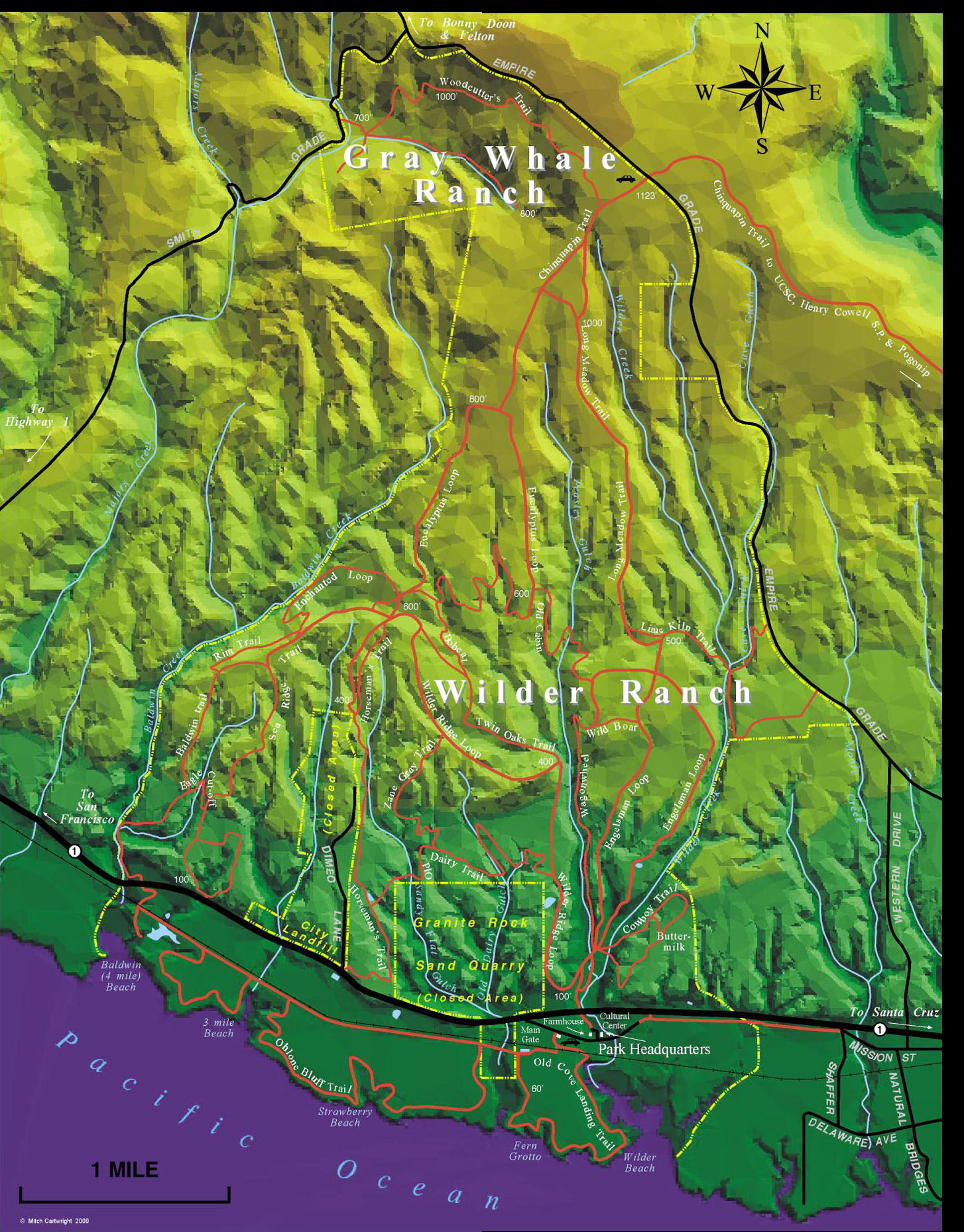
(This map was developed by Mountain Bikers of Santa Cruz. Click it for a full-size version (put together by Dave Luke).)
  

OTE Ratings: O8/T6/E6
Distance: 10 - 19 miles
Time: 1 - 4 hours
USGS 7.5' topo: Santa Cruz, CA (lower park); Felton, CA (new "Gray Whale" addition)


Description

The terrain ranges from open, grassy benchlands above (north of) the farms along the beach, to some trail just above the beachside bluffs, to deep redwood-filled canyons. Ocean & city views, a neat sea cave, some wildlife (hawks, herons, egrets, pelicans, seagulls, cormorants, deer, rabbits, bobcat, coyote, seals and sea lions). Climbing is moderate (highest elevation ~ 800'). Many trails, a reasonable amount of nice and challenging forested singletrack with several creek crossings, some dry, some wet. Best on a cool day or a day with high overcast, but clear underneath. Bring binoculars. Redwoods, madrone, a small grove of large eucalyptus, blackberry bushes, and plenty of poison ivy can be found here.

Directions to the start

(N 36.96014°, W 122.08556°)
The park entrance is on the south side of highway 1 (which is an east-west road here), about 1.5 miles west of Santa Cruz. There is a very large turnout just east of the park entrance; parking there can save you the $6 park entrance fee. But beware: on one Easter ride, we had three car windows broken, and three car stereos stolen. Maybe the $6 park entrance fee is worth it.

Ross Finlayson adds (7/16/96): Yes, the $6 park entrance fee is definitely worth it. I've just heard of another break-in to a car parked alongside highway 1. You're much safer parking inside the park. Yes, the $6 fee is stiff, but the staff at Wilder Ranch have generally been very supportive of mountain biking, so this park is worth our continued support in turn.

The ride

Several route possibilities exist in the park; I'll try to describe three of my favorites here. If you have parked at the turnout on the highway, go west along highway 1 to the park entrance. Turn left and go up into the park, past their entrance kiosk, and past the parking lot. If you parked in the lot, go on down to the ranch house area. Go on through that area (if the park is staffed, you can get a poor topo map from their bookstore; but the Krebs map's coverage is better), and through a tunnel under highway 1.

A couple of minutes later, make the sharp left turn to start heading up the hill. (The Krebs map calls this "Wilder Ridge Trail".) This takes you up a short steep part, then some rolling/flat land.

[Option 2: Dairy Mill Trail. See below.]

After the main trail does a few little down-and-up dips, there is another short but even steeper part, to a junction with "Twin Oaks Trail". Go left to stay on Wilder Ridge Trail. A little more steep climbing gets you to a great viewspot, with views of beaches, farms, much of Santa Cruz, and around the Monterey Bay.

Above the viewpoint, there is some more flat/rolling riding, one singletrack trail (the top of Zane Grey trail -- an alternate route up here that comes up from Dairy Mill trail), then a fun little side loop can be had by taking the "Horseman's Trail" singletrack down along next to the gravel road by the dump. After about 1/3 mile?, cut over to the gravel road and climb back up. Take a hairpin left turn onto a dual-track trail, which goes a 2/3 mile or so to the southern entrance to the "Enchanted Loop". [Yeah, I know, more precision is needed here]. Take this beautiful trail through the redwoods down to Baldwin Creek, upstream along it, and make the difficult climb out to the Old Corral.

[Option 3: Eucalyptus Grove & Big Meadow. See below.]

From the Old Corral, we usually take the singletrack that descends gradually to the east, into the draw. It makes three often-dry "stream" crossings. Recent (6/93) trail work has made all three crossings passable, although the third one remains tricky.

Shortly after the third crossing, the trail widens into a dirt road, take that up a short way along the large meadow, and there's another singletrack off to the right.

This trail (not shown on the Krebs map) goes over to Peasley Gulch and the east side of the park. We take that one, for a nice, winding descent through oak, madrone & poison oak, across a creek, and another climb. There used to be two or three quite challenging spots along here, but trail maintenance has made this trail quite ridable the whole way. At the end of the trail (at the top of the climb), we turn right onto a dirt road, zoom down a few hundred yards, and then rightish again, onto the trail that Krebs calls "Lower Peasley Gulch Trail". (We call it "Dead Boar Trail" because we found one there once.)

At the bottom of Dead Boar Trail, you hit the main dirt road that leads up into the east half of the park. Bear right onto it, and you can return to the Ranch area. (That's the 2.5- to 3-hour trip.)

Option 2: Dairy Mill Trail

[EASY TO RIDE but HARD TO DESCRIBE -- NEEDS TO BE REFINED]

An additional loop can be done at the end of the main ride, by re-ascending the first couple of steep parts of Wilder Ridge Trail, then turning left onto Dairy Mill Trail (not shown on the Krebs map). It's a little single-track trail that climbs 10 or 12 feet up to the left of the trail, then leads out onto the grasslands. This trail skirts along the edge of the flattish grasslands, just above a small canyon full of pines & madrones. After a couple of miles, it hits the bottom of "Horseman's Trail" (bear left), and then does some down-and-ups, to end where Dimeo Lane hits Hwy 1. Cross the highway and turn right to take the dirt road that parallels the highway. It dips down into a brussels sprout field, then climbs out the other side. Follow this road out toward the ocean, and turn left onto the trail by the railroad tracks (the Krebs map calls this "Ohlone Bluffs Trail"). There are several little loops that go around little brussels sprout fields (I like to take them all); I think it's the third one that leads to a long, nice trail above the bluffs. When it finally gets you back to the railroad tracks, turn right; then turn right to go past a farmhouse or two and connect to the "Old Cove Landing" trail.

Option 3: Eucalyptus Grove & Big Meadow

If you didn't get enough climbing yet, you could turn left onto the dirt road, and take it on up to the Eucalyptus Grove at the top of the big meadow. Watch carefully as you descend the east side of that meadow -- there's a fun singletrack loop off to the left, that goes down into Upper Peasley Gulch, then returns to the road. Once back on the road, you can continue down it, to where it becomes singletrack with some challenging creek crossings (all dry last time I was here), and heads back toward the Old Corral. Just before you get to the Old Corral, you can take Bobcat Trail (this one even has a sign) to Twin Oaks Trail, which returns you down to the main trail, just below the "great viewspot".

©1995-2019 Doug Landauer

-----

For more information

-----
Return to the mountain biking page

©1995-2019 Ross Finlayson