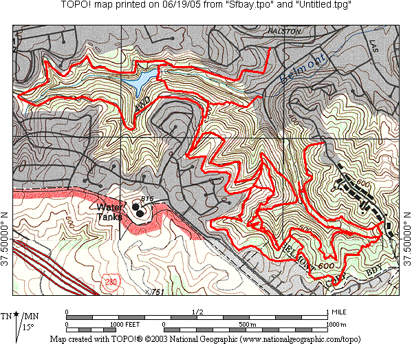
Water Dog Park (Belmont)
Officially, it's "Water Dog Lake Park", and the ride includes
the adjoining "John S. Brooks Memorial Open Space Preserve".
And it's a reservoir, rather than a Lake.
OTE Ratings: O7/T7/E7
Distance: 6-8 miles
Time: ~ 2 hours
USGS 7.5' topo: San Mateo, CA; Woodside, CA
Description
Dirt road & singletrack, dry chaparral hills, some challenging
climbs. Edges of the park are up against houses, apartments, and
condos, making it an anomalous island of nature in the midst of
suburbia (like
Lake Chabot park is).
We have seen a squirrel tail, and a (Cooper's?) hawk here.
Directions to the start
(N 37° 30.6', W 122° 18.0')
From U.S. 101, take the Ralston Av. exit if you're coming from the
south. From the north, I beleive it's called Marine World Parkway.
Head west, past El Camino Real and The Alameda de las Pulgas. Just
past this last street, keep your eyes open for Lyall Way on the
left, just as the road begins to climb. Turn left on Lyall. You
will come to a stop sign at Lake Road. Park on the left side of
Lyall just past this stop sign. The entrance to Water Dog Lake is
at the corner.
(Ross Finlayson adds:)
A newer (and probably better) place to park is the parking lot at the end of Carlmont Drive.
To reach this, turn left on Lake, then right onto Carlmont. Carlmont will dead-end at the parking lot.
|
|
If you prefer to come via I-280, take 92 east and then take the
first exit (Ralston), go up over and most of the way down the
hill, to turn right on Lyall, then follow above directions.
The ride
Ride up the dirt road for 2.3 miles, up to the park's Hallmark
gate, go left (down) across the canyon, and then climb some
singletrack. After this, you continue along singletrack right
behind dwellings, for a mile or so.
(Updated description by Ross Finlayson)
At this point the trail used to cross a private driveway.
However, in recent years it has been rerouted to stay below the homes
at the top of the ridge. Follow the "Trail" signs, and you can't go wrong.
A steep but short downhill where you might choose to walk, with a
V-shaped cement culvert at the bottom, is followed by some choice
singletrack[*], winding past some tricky creek crossings, riding
over a nearly-buried car. (Our best estimate is that it was once a
'57 Pontiac.) This trail ends at a T; you can go either way. Go
right and you can ride up to an extremely challenging hill to climb
(none of us made it up), that gets you out to a different street
(Whiteridge Road, I think).
There's another trail to the left, just before that hill, take that
and traverse along the side of the canyon.
As you descend along this singletrack, there are three spots where
you could ride down very steep short trails, to the trail in the
bottom of the canyon. The third one is the one Jae rode up.
Several others of us tried (not me!), Bob made it very near the
top, and Paul, Debbie and Tim got pretty far up there.
If you choose not to go down any of these side trails, the trail
gets a little overgrown (but not with poison oak), but is mostly
rideable, down to a clearing.
If you go sharply left here, you're going back up along the bottom
of the same canyon, to the bottom of those steep short trails. We
go straight across instead, to a climb that's mild at first, but
then turns straight up the ridge and gets quite challenging.
[*]Update by Ross Finlayson:
As an alternative to the singletrack that drops down to the buried car,
there's now a new trail - parallel to this - further up the side of canyon.
Look for the trail branching off to the right, shortly after the concrete
culvert.
This new trail - which has no fewer than twelve fun switchbacks -
was built by mountain biking volunteers, under supervision from the
City of Belmont.
(Kudos to the City of Belmont for being so bike-friendly!.)
©1995-2019 Doug Landauer

For more information
Return to the mountain biking page
©1995-2019 Ross Finlayson