Soquel Demonstration State Forest (north of Aptos)
(Often referred to as "the Demo Forest" or "SDF")
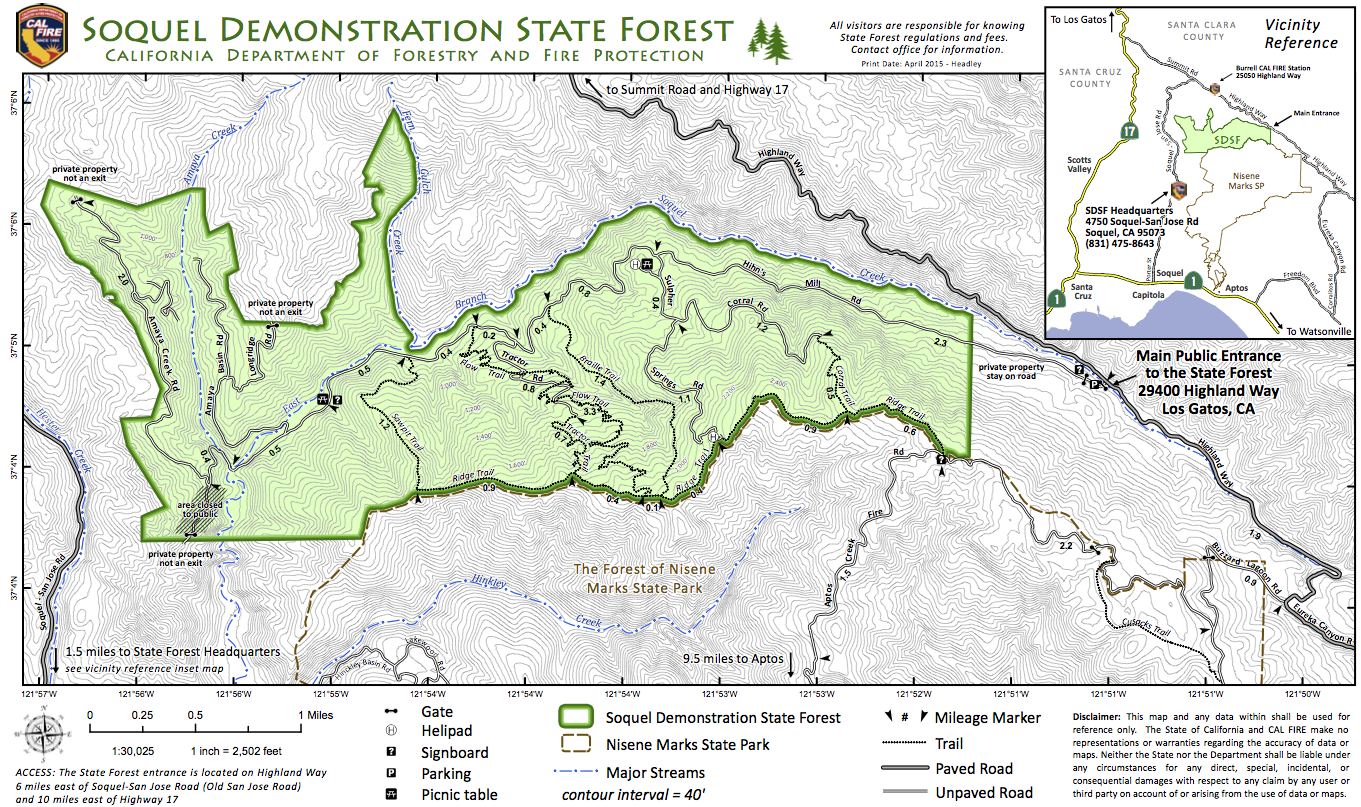
(This map is from "CalFire". Here's
the original
(a PDF document))
OTE Ratings: O8/T9/E7
Distance: 12-24 miles
Time: 2-6 hours
USGS 7.5' topo: Laurel, CA (most of the park); Loma Prieta, CA (start & end of the ride)

Description
At least two loop rides can be started here; you can wait until the
middle of the ride to make the decision about which one to take.
Starts out by climbing up the paved road, then climbing up some
sandy/dusty dirt road, then some fun and technical singletrack
(some of which was recently bulldozed into a boring fireroad),
down into the SDF, with a decision at the bottom.
The SDF actually borders on
The Forest of Nisene Marks
State Park, and you can fashion some nice long rides by
combining these two areas.
Directions to the start
(N 37.08199°, W 121.85074°)
Take Highway 17 to Patchen Pass ("The Summit") and go southeast on
Summit Drive. (That's a right turn if you're coming from Santa Cruz,
else it's a weird crossing over 17.) Go 10 miles as Summit becomes
Highland Way, and does a sort of right-then-left jog at Mt Bache Road
and Spanish Ranch Road, to a parking spot with a small but bright
green "Soquel Demonstration State Forest" sign.
Note: The section of Highland Way roughly 1/2 mile before this parking spot
has historically been subject to frequent (and large!) landslides.
Ocurrently, even though the road is marked closed at this point, it is still driveable.
The ride
Ride on up Highland (still southeast), turn right onto Buzzard
Lagoon (Ormsby Road goes the other direction here), then right onto
Santa Rosalia Mountain Rd (no sign -- it's a spot where Buzzard
Lagoon continues straight and down, while you make a sharp right
and go further up). Up for a while, then a little down and more
up, you come to a gate, then some more up, and down to the Santa
Rosalia Overlook. Here, take the singletrack down into Soquel
Forest. One leftish turn is hard to find -- it's a "Y" just below
the Corral Trail turnoff, off of Sulphur Springs Road (formerly
some of the nicest singletrack in the Forest), to Ridge Trail and
Tractor Trail. I used to recommend avoiding the upper end of
Corral Trail, since the singletrack Sulphur Springs trail was a
very fun one, but the Powers That Be ruined it by grading it into a
dirt road.
At the bottom, Tractor Trail dead-ends onto Hihn's Mill Road (dirt);
turn right for a gradual climb back to the parking spot.
©1995-2019 Doug Landauer
For more information
Return to the mountain biking page
©1995-2019 Ross Finlayson