OTE Ratings: O2/T3/E9
Distance: ~10 to 15 miles?
Time: 2 to 4 hours
Climb: 1500' to appx. 3000', which feels like 6000.
OTE Ratings: O2/T3/E9
Distance: ~10 to 15 miles?
Time: 2 to 4 hours
Climb: 1500' to appx. 3000', which feels like 6000.
![]()
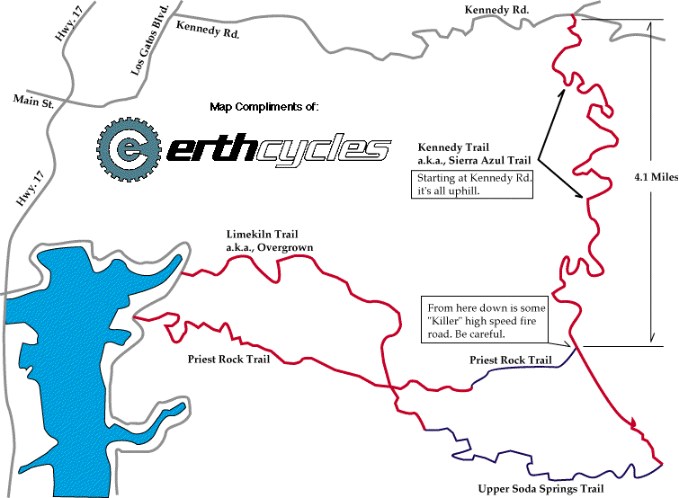
Actually, it's not *quite* as bad as that, but the first time I went there, I was shown this area at its absolute worst, weatherwise (hot), boring trailwise (*all* dirt road), and crowdswise. I've since been shown better routes in here, which raised the "O" rating from its initial nadir. It's still among my least favorite rides, though, so take the biased descriptions with a grain of gatorade powder.
Well, actually, there is one other fun way down, called "Moody". Get there by turning right at that junction, climbing just a little bit more, to a peak with a nice view if it isn't too smoggy. Continue down the main fire road for another few hundred yards, and spy a rocky singletrack that climbs off to the left. Go up it, then lower your seat for some seriously steep, rutty downhill sections. This singletrack drops you back out onto a fire road that then descends back to Alma Bridge Road. Now go home.
Masochists' route: stay on Alma Bridge Road, up to the top of a slight rise, where a dirt road and a gate go off to the left. This is Priest Rock Trail. Go on up that, and you have an opportunity to climb, in the sun, for the next hour or two. At the top, there is a road to nowhere that goes off to the left, but you (once you've mostly recovered) get to go on downhill for a ways, to a four-way junction. To the left is "Overgrown", a fun singletrack descent, with a fair amount of poison oak, but not too much of it sticks out into the trail. The other choice adds about an hour to the trip: bear right and you will go downhill some more, cross a couple of creeks, and then climb climb climb some more, on a fire road that Dave calls "technically steep", up to near the highest point in this OSP (around 2800 feet elevation).
Left onto a narrower, but not quite single, track is the only non-dead end here. You do some fun down-and-up swoops, to test how well you "do momentum", and then some quite steep downhills, until you find the top of the trail/road from Kennedy Road. Bear left, and you get to descend some more steeps, to the aforementioned junction. Turn right here, to go on down Overgrown.
©1995-2019 Doug Landauer
![]()
Return to the mountain biking page
©1995-2019 Ross Finlayson