Purisima Creek Redwoods Open Space Preserve (Woodside)
This map is courtesy of John Blenio.
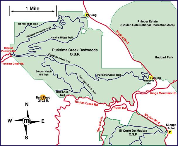
You can also click on a point in this map to see a high resolution topographical map for that area.
(Topographical maps created with TOPO!TM ©Wildflower Productions)
OTE Ratings: O7/T7/E8
Distance: 10 to 25 miles
Time: 2 to 5 hours
Climb: 2560 feet
USGS 7.5' topo: Woodside, CA

Description
Wonderful switchbacking singletrack descent through open, chaparral-
covered hillsides; the descent is steep enough that you see the
tops of your companions' helmets down below. At the bottom is a
redwood-forested gulch. Optionally, a steep climb towards Tunitas
road and a lightly-traveled road connection over to
El Corte de Madera OSP.
During the rainy season, they usually close Purisima's
only singletrack trail. Rumors abound that they (the MROSD) are
about to close that trail permanently :-(.
Directions to the start
(N 37° 27.0', W 122° 20.3')
Skyline (highway 35) west of Woodside ... 92 to 35 and then
south for 3 or 4 miles, or take 84 to 35 and go northwest for
4 miles (or maybe 84 to King's Mountain Road to 35, then
turn right, and go 3 miles or so).
The ride
Purisima can be done as a medium-length ride, my favorite way that
stays in this OSP is to go down Whittemore Gulch, and then up the
main fire road (not Harkins' Gulch F.R.); you can make an optional
loop up Borden Hatch Mill and down Grabtown Gulch Trail.
My favorite ride here, however, is this one: Go down Whittemore Gulch,
across the bridge, left to start up the main fire road. Turn right
onto Borden Hatch Mill Trail, climb (big climb) to the top, then turn
right and go out to Tunitas Creek road (paved). Turn left onto it,
climb a mild mile on this road, take the sharp right turn onto Star
Hill Road, climb a bit more, to Swett Road, then descend, fast, to
gate CM08, which is an entrance into
El Corte de Madera OSP.
Ross Finlayson notes: The Whittemore Gulch trail is closed to bikes during
each wet season.
For the current status of this (& other MROSD trails), see the MROSD's
trail conditions page.
For more information
Return to the mountain biking page
©1995-2019 Ross Finlayson