Henry W. Coe State Park (east of Morgan Hill)
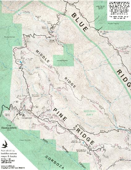
(This map is a reduced version of one of Lee Dittmann's
official park maps.
To purchase these maps, see
Lee Dittmann's site.
Additional maps - showing more trail information - are also
available from Bill Levey's site.)
|
OTE Ratings: O9/T7/E10
Distance: 9.5 miles (Middle Ridge Loop)
USGS 7.5' topos:
| Mount Stakes, CA
(northern Orestimba Wilderness - closed to bikes) | Wilcox Ridge, CA
(north-eastern Orestimba Wilderness - closed to bikes) |
Mount Sizer, CA
(Park headquarters, Middle & Blue Ridges) | Mississippi Creek, CA
(Los Cruzeros, China Hole, Willow & Pacheco Ridges, southern Orestimba Wilderness (the latter closed to bikes)) | Mustang Peak, CA |
| Gilroy Hot Springs, CA
(Coyote Creek and Hunting Hollow entrances) | Pacheco Peak, CA
(Burra Burra Peak, Dowdy Ranch) |
|

Description
"Gear #1 is your friend" - Paul Nam
Henry W. Coe State Park (or "Coe" for short) is a large and very rugged park,
located in the remote southeastern corner of Santa Clara County, east of Morgan Hill and Gilroy.
The good news about Coe is that it contains some of the best downhill singletrack in the southern Bay Area.
The bad news is that it also contains some of the Bay Area's steepest fireroad climbs.
To best enjoy this park, you should be in fairly good shape.
The best time to visit Coe is during the spring or autumn.
Summers can be very hot (90-100 degrees), and during the winter, the park's singletrack trails are closed for 48 hours after rain.
Whenever you choose to go, be sure to carry plenty of water.
Some more information about Coe can be found on the official Henry W. Coe State Park site.
This includes a page about mountain biking at Coe.
It would take several days to fully explore this huge (80,000+ acre) park,
even without including the "Orestimba Wilderness" in the north of the park.
(This area is closed to bikes.)
The most popular ride is the 9.5 mile "Middle Ridge Loop", starting at the park headquarters.
This ride is described below.
Directions to the Park
Main entrance (park headquarters)
N 37° 11' 12", W 121° 32' 50"
(Use this entrance to ride the Middle Ridge Loop.)
See the directions posted on the official Coe site.
Coyote Creek and Hunting Hollow entrances
(Coyote Creek: N 37° 05' 59", W 121° 28' 21";
Hunting Hollow: N 37° 04' 34", W 121° 27' 59")
(Use these entrances to explore the southern end of the park.)
See the directions posted on the official Coe site.
Note that there are no services (including water) at the Coyote Creek entrance.
The Middle Ridge Loop
The start
This loop is best done in the clockwise direction.
Begin by taking the dirt road ("Manzanita Point Road") that starts next to the park headquarters.
(Don't be distracted by the singletrack that you'll see near the park headquarters;
none of this is open to bikes.)
Do not take the left turn onto "Hobbs Road" (unless you're a masochist).
Instead, continue for roughly another mile, and watch for the "Flat Frog Lake Trail" on the left.
(There are actually three trail entrances clustered together on the left of the fireroad.
"Flat Frog Lake" is the leftmost of these; the other two are closed to bikes.)
The "Flat Frog Lake" Trail
This sweet and beautiful singletrack trail winds around the hill,
eventually joining "Hobbs Road" (fireroad) near Frog Lake.
There are no steep sections on this trail, but it's remarkably narrow for a legal
trail, and this makes it a lot of fun.
The "Frog Lake" Trail
Continue to the right along "Hobbs Road", as it crosses
an (often dried-up) creek
(the Little Fork of Coyote Creek).
Then, after a short climb, turn right onto the "Frog Lake" trail.
This singletrack drops down beside a small lake, then climbs up
the hillside towards Middle Ridge, at which point you turn right.
The singletrack descent (Middle Ridge Trail)
You now begin a more than 1700 ft singletrack descent over about three miles.
Apart from one short (but steep) uphill section about 1/3 of the way through, the trail is almost all downhill, becoming progressively more technical as it gets lower.
You'll also notice the countryside changing:
from open grassland to forests of manzanitas and madrones.
About halfway through you'll see a trail (the "Fish Trail") branching off to the right.
Ignore this; it's closed to bikes.
The trail ends beside a creek, in an area named "Poverty Flat".
This is a good place to stop for lunch, before beginning the climb back out.
The climb out (option 1: more direct, but painful)
Shortly after crossing the creek, you'll reach "Poverty Flat Road".
For the most direct way back, turn right and take this road back to the park headquarters.
The first section of this climb is brutal, climbing 1,400 feet in 2 miles.
(I call it "the Hill from Hell".)
The climb out (option 2: more hassle, but more singletrack & less pain)
(This is the alternative I prefer.)
Turn left on "Poverty Flat Road", then cross the creek and follow
it downstream, along its right-hand bank (i.e., on the side closest to the park headquarters).
There's a rough trail here that leads to the China Hole trail crossing.
You will have to push or carry your bike much of the way;
some of the trail is washed out (being so close to the creek) and unrideable.
In places you'll have to carry your bike over large boulders.
This is a bit of a pain, but the resulting singletrack climb makes it worthwhile.
Ride the China Hole Trail up to the Manzanita Point campground, and then back to the park headquarters.
This whole trail is rideable, and is not excessively steep.
On average, it's no steeper than the "914" trail in
ECdM,
although it is much longer.
Randell Leach (randell.leach@wellsfargo.com) describes a variation on the Middle Ridge Loop described above:
We thought we would
venture out a little farther past Poverty Flat-- excellent but it did kick
my ass. From Poverty Flat climb up the switchbacks and take the first
fireroad on the right
["Mahoney Meadows Road"]
that drops down into the valley (its in a couple
miles). From there cross straight through the stream, up a steep fire road
and look for the tiny singletrack on the right (near a left hand turn) that
heads up to
[the top of Mahoney Ridge]. This is a GREAT climb. The trail switches back
over your left shoulder at the "bathtub", but it is hard to see because all
of the leaves. Head up to the top of
[Mahoney Ridge]
then take the singletrack
over your right shoulder down to China Hole-- its a blast!!!!!!!!! When you
get to the river you cross and suffer up the other beautiful China Hole
singletrack to the fire road/to Rangers' Station. This is an excellent, but
serious little ride. Bring more food and water than you think, you'll need
it-- there is quite a bit of climbing going on.
Mark Rosenberg (mr@tibco.com) adds the following advice:
- It is tempting to take beginning riders on Flat Frog Trail. However,
speaking from experience, the exposure and trail narrowness will
freak out many of them. My wife took a nasty head-first fall into
a dry stream bed when she lost her balance dismounting to walk her
bike around the stream crossing.
- There is another alternative way to get out of Poverty Flat that
I frequently use: turn left as in option 2, but look for the
Cougar trail on the right. Take this, cross the stream, and
then follow the trail uphill. After about 1/2 mile, it joins the
China Hole Trail, near where it reenters the trees. The trail is
very steep and not well used so much of it is unridable. It does
however eliminate the hassle of dealing with the Coyote Creek
stream bed and is considerably more direct.
David Hornby (hornby@sabretooth-92.eng.sun.com) - a volunteer at this park - advises:
Before doing this ride or the Blue Ridge loop shown on the map, riders should
check with the ranger station on the condition of the Middle Fork of Coyote
Creek in Poverty Flat. If it's running high, it is dangerous at best
to cross.
Riding in other parts of Coe
From the Park Headquarters entrance
Some people have taken Hobbs Road all the way to "Blue Ridge Road",
which runs along "Blue Ridge" (the next ridge across from "Middle Ridge").
This is said to be insanely strenuous;
part of it climbs 1,500 ft in just 1.3 miles!
(See Todd Schmidt's illustrated description of this route; he uses its old name:
the "Northern Heights Route".)
From the Coyote Creek entrance
The "Coit Road" (dirt road) - which begins at the Coyote Creek entrance - is quite scenic,
and not excessively strenuous.
I've ridden this as far as Kelly Lake.
My favorite ride in the Coyote Creek area is to take the Coit Road to Wasno Road
to the start of the Domino Pond trail
(N 37° 07' 18", W 121° 26' 54")).
Then, take the Domino Pond trail (which changes its name to "Cattle Duster")
to the "Grapevine" trail.
The "Grapevine" trail (also nicknamed "Rock Garden") is a very nice singletrack descent (with some fun rocky technical sections).
It drops back down to the Coit Road.
At this point you can also continue along "Anza" trail (fun singletrack!)
as you return to the Coyote Creek Entrance
John Birge (john.birge@ebay.sun.com) describes another ride in this area:
Willow Ridge up from Los Cruzeros is a steep technical single
track, more fun coming down than up. Willow Ridge also merges
with Crest Trail which is a Firetrail and runs along the top
of, you got it, Willow Ridge. One of my favorite rides is to
come in from Coyote Creek up Coit trail to Cross Canyon. Cross
Canyon is a great Single track, decending into Kelly Canyon,
then climbing back out to Willow Ridge/Crest Trail at
Coit Lake (a beautiful sight). Left on Crest Trail and
past the Landing Strip you mentioned and on to Willow
Ridge Single track for a screaming descent down to Los
Cruzeros. From there it's a grinding climb back out up
Coit to Lost Springs, another single track, which is more
forgiving than Coit proper which has a couple of walls on
the way out. Lost Springs drops you back on Coit about half way
up.
At this point your gonna be feeling the ride. But if you
so inclined you may want to follow Coit back to Cross Canyon
only this time go right, to the Tee left to Coit Spring and
on to Grapevine Springs trail another screaming technical
descent.
From the Hunting Hollow entrance
The hunting Hollow entrance lies at the base of a valley,
from which you ride north/east to climb up to the top of a ridge.
Once on this ridge, you have a choice of attractive
trails/fireroads that are quite mellow by Coe's
usual standards.
Unfortunately, there appear to be no easy routes to the top of the ridge.
Even the best route - the "Lyman Wilson Road" - is a strenuous climb.
(Despite its name, much of the "Lyman Wilson Road" is actually singletrack.)
The best ride in this area is the "Grizzly Gulch Trail":
almost 4 miles of gorgeous, rustic singletrack.
This trail is
best ridden in the east-to-west direction - i.e., towards the
Coyote Creek gate - giving you a ~1200' net descent. To reach the start of
the trail (i.e., the eastern end), you must first climb to the top of the
ridge (e.g., taking the Lyman Wilson Road and the "Bowl" trail).
(If you have a GPS
receiver, you can find the start of the Grizzly Gulch trail - a left turn
off of "Wagon Road" - at
N 37° 05' 34", W 121° 25' 07").
For more information
Return to the mountain biking page
©1995-2019 Ross Finlayson