'
Cannell Plunge
The "Cannell Plunge" (near Kernville, Kern County)

Thanks to Berry Stevens for this ride description (October 2005).
Taking the Plunge
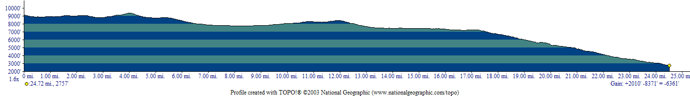
Eight of us, plus my non-riding wife, Pam, headed up to Kernville, CA to ride the Cannell Plunge this past weekend Oct 15-16. The Plunge is now my standard for what constitutes an "Epic" ride. I has it all, stunning scenery, challenging trails of all varieties, high altitude climbing to give you a real workout, views to distract you while riding and just plain fun. For the metric weenies: 1:20 min shuttle, with a drop @ 9200' rolling single track up to 9400', ~30 miles depending on whether you climb Sherman Peak or a couple of the other variants, 2500' of climb, 9000' of descent, including the Plunge itself at the end which is 4800' of descent in 8 miles. You'll want a drogue chute for this one.
Figure a 4-5 hour ride time depending on fitness and how many photos you take. A camera is a must for this ride.
So now you'll want to know "How do I do this ride?" Here's the info.
Getting there
I-5 to Hwy 46 East to Hwy 99, from here you have a choice, the shorter but slower scenic approach or the longer, but higher speed (and still scenic) route thru Bakersfield. If you continue straight East across Hwy 99, Hwy 46 becomes Famoso Rd. then a left on Tule Rd, then another left on Bakersfield Glennville Rd to Glennville, where you turn right and take Hwy 155 up over Greenhorn Summit and down to Wofford Heights, then a left and a short drive up to Kernville. This route is a 10 for scenery, but is 40-50 miles of twisty, turny narrow road. Not for those prone to carsickness and no fun at night. In daylight, it's beautiful and well worth driving. Or you can take 99 South to Bakersfield, where you pick up Hwy 178 North, up thru Kern River Canyon, also a feast for the eyes, and up along the West shore of Lake Isabella to Kernville. Driving time for both is about the same, an 1:25 minutes. Go in one way, leave by the other.
How to do it
This ride requires a shuttle, unless your name is Lance. Hook up with
Mountain & River Adventures for the shuttle; they're the only game in town. It costs $30 for a 1:20 minute shuttle ride up the Kern River Canyon and Sherman Pass Rd to the top of Sherman Pass. The drive to Kernville and the $$ for the shuttle are worth the shuttle ride alone. I've never seen scenery and landscapes like it. Be sure to get a window seat on the van.
Check these websites for ride descriptions and details.
Things to Know
There's a fairly narrow time window to do this ride, unless you can tolerate high exertion at temperatures near 100 deg. You spend the first 3/4 of the ride above 7000', so the trail isn't clear until summer, when it's hot, very hot, near or over 100deg most of the time, in town and on a lot of the ride. The higher elevations will still be in the 80's over the summer, plus the meadows will remain soggy until the fall. You would be challenged to carry enough fluids to do it in the Summer. So, from October until the snow flies is the best time to ride the Cannell Plunge. The day we rode, it was near 80 in town, but the low 40's @ the shuttle drop and for much of the first 1/2 of the ride. Regardless of when you ride, bring plenty of both water and your favorite sports drink plus plenty of food and layered clothing. Pace yourself, the most challenging part of the ride is at the end, The Plunge, and if you're tired or dehydrated, it could lead to serious consequences. It's steep and technical in places; you need to be on your game when you get to it. Leg armor is a great idea; even if you don't biff, the vegetation will shred your shins, there's no trail maintenance up there. At the point where you see the sign for Cannell Trail, alongside the meadow, DON'T take it. Stay on the fire road and it will save you getting wet slop all over you and your bike as well as avoid a hike-a-bike back up to the fire road. At least one of the ride descriptions describes this, it's great advice.
We did "Just Outstanding" the next day, which was a shuttle ride up to Greenhorn Summit to a ski area parking lot on Rancheria Rd. The single track portions of this trail are guaranteed to put a BIG smile on your face. Twisty, fun and highly enjoyable; a great counterpoint to the previous day. The latter half of the ride is a LONG descent on Old State Highway, a smooth, unpaved road. The virtue of this part is the scenery, which is nearly as distracting as it was on the Plunge; the road itself is a snooze unless you want to push the speed and explore the limits of traction on a sandy road surface.
Bottom line, the whole area offers scenery like no other place you've ever been and the trails are unique and will keep you highly entertained. Go do it.
©1995-2019 Berry Stevens
For more information
Ross Finlayson's
GPS topo map (warning: 7 MBytes)
and
elevation profile
from his ride here in October, 2006.
Return to the mountain biking page
©1995-2019 Ross Finlayson