Distance: ~9 miles
Time: 1.5 - 2 hours
USGS 7.5’ topo: Palo Alto, CA; Mindego Hill, CA
|
OTE Ratings: O7/T6/E4
Distance: ~9 miles Time: 1.5 - 2 hours USGS 7.5’ topo: Palo Alto, CA; Mindego Hill, CA |
|
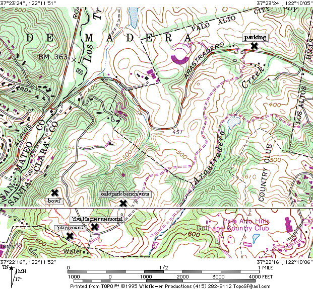
![]()
I’ve seen a surprising amount of wildlife here, considering how close it is to civilization: deer, owl, tarantula, hawks, some weird little black mole/vole creatures, and 1 guy fishing in the lake, with one of those weird floating wader-things on (like waders but with an inner- tube built in, around chest-height).
(Alternate route: from northern Mountain View, you can take San Antonio over 101, to Charleston (the first light), and then turn right. Charleston becomes Arastradero Road as it crosses El Camino -- take it all the way to Page Mill. Turn left onto Page Mill, and then right to get back onto the other segment of Arastradero, as above.)
You’ll pass the bottom of a singletrack trail on your right, and then you’ll see a barn, with another singletrack trail going off to the left just before you climb up to the barn. Take that singletrack, ignore the inviting downhill that it crosses, and go on out to the high point, from which you can see a residence. (I believe that this house is still owned by the family which donated the land as a public preserve.)
Right about here is the high-altitude point of the trip, around 600 or 650 feet. Make the left turn that goes down a bit and then climbs to the edge of the park (where it borders on Foothills Park), and follow this trail up along the park fence, then down and bear right where it splits, to climb up a few hundred yards, to "The Bowl". It looks like it might once have been the ranch’s water storage tank -- steep, built-up sides, and flat bottom. Ride across it a few times and try to use your momentum to get up the sides. Now try it slowly, without using momentum.
Leaving from the bay side of the tank, there’s a steep and loose singletrack that returns you toward the gravel road; bear left (down) on to it, and go down about 200 or 300 yards, until you get to a tree on the right, that marks the start of another singletrack trail. This trail takes you all the way back down to lower than where you started, with some fun swoops and ups and downs.
Note: recently (spring 1994) the bottom half of this trail was closed to bikes. You have to go onto a dirt road at the first or second opportunity; the description below has not yet been updated to reflect this recent closure.
At the bottom, you cross a probably-dry streambed with a lot of poison oak growing in it (the trail through it is not overgrown, but don’t fall into it). Go through and turn right, to climb back up a little, to an Arastradero Park entrance gate (not the one we started at). Go on in, onto the dirt road, cross MeadowLark trail, and descend to Corte Madera trail.
Turn (sharp!) right at the bottom of the hill, onto Corte Madera trail, and watch for a small singletrack trail on the left. As this goes across the south end of the lake, there are some challenging roots to cross, and some more poison oak, so watch for it. Then turn left to go along the east side of the lake, out to a paved road. Go up the road and then left onto today’s final stretch of singletrack. That takes you back down to Corte Madera trail -- turn right to return to the parking lot.
©1995-2019 Doug Landauer
![]()
©1995-2019 Ross Finlayson